Saturday, November 22, 2014

Snow before Thanksgiving?

Possible Snow for Richmond Nov 26th

This week is shaping up to be an interesting one for Richmond, VA! First, temperatures will keep climbing from a low of about 35-36 tonight all the way up to the mid 70s on Monday!!

This is in response to a potent 500mb shortwave that is abnormally far south. At least I can't ever remember a time when a shortwave in the Southern stream had so much energy and intensify like this one will. Here is the 11/22 NAM 12z initialization.


At the surface, a low pressure center is forecast to form in the lee of the Rockies. Another low that has already formed in Alberta will move down into the upper plains and combine with the Rockie low. It looks like this low will rapidly intensify by the time it moves over the Great Lakes by forecast hour 48 (12Z 11-24). The GFS has the low below 972mb! This will provide plenty of warm air advection for us in the warm sector, giving us the near 75 degree highs on Monday. As the warm front moves through on Monday, the NAM has Richmond getting over an inch of rain, but the GFS is only showing ~1/4 of an inch.

Snow!!!

The big excitement for me is the possible snow on Wednesday.


After that shortwave moves through, the GFS is showing a second shortwave moving throught the bottom of the main trough. A low pressure is forecast to form off the Carolina coast and moving quickly up the Eastern shore. This low may also bomb out off the coast of Newfoundland. As it bushes past Virginia, wrap around moisture, and a column that looks like it can support freezing precip, and a surface right 34-35 could be our first snowstorm and our first big snowstorm.

If it verifies, I just hope it doesn't cause any trouble for my Dad who is coming to visit us for Thanskgiving. He gets here Thurday morning!

Thursday, July 17, 2014

My Weather Station

My Davis Vantage Pro2

I finally got my weather station up-and-running and reporting to the Weather Underground!
URL: http://www.wunderground.com/personal-weather-station/dashboard?ID=KVAHENRI14

I wanted it to be more than just a way to check the outside temperatures. Also, I didn't want to have a full computer running all the time to gather the data (The Davis WeatherLink software only runs on Windows). So I decided to buy a rabbery pi.(http://www.raspberrypi.org/): a $35 mini-computer the size of a credit card.
How cool is this little thing!!!

The little dongle sticking out is a USB Wireless adapter. Which actually works amazing on the Rasbery Pi!!! All I had to do was plug it in and press the WPS button on it and my router. Then, it was connected!!! As for an Operating System, I choose Raspian: http://www.raspbian.org/. I liked it MUCH better than Arch Linux. I tried Arch first, but man, I had to configure every little thing manually - like DHCP settings. Raspian seems like it is basically Dabian, but smaller and built for the Pi. It has been working perfectly for me!!!

As for the software, there are these amazing people over at WeeWX: http://www.weewx.com/. They have software that will interface with almost any personal weather station and its built for Linux! It's really easy to set-up, just follow their directions. They also have a large user group which actively posts on the forum and answers many technical questions. They only thing I did wrong (and it took me almost two weeks to figure out) is that you have to see up a MySql database first to store your weather data. I assumed their code would do it for me (dumb of me). However, even I was able to download MySQL, set up a database, a table, a user (weewx) and set a password. 

Somehow, I finally did it! I am very proud of my weather station (counsel pic below). Thanks to my AMAZING husband for buying it for my birthday!!! LOVE you babe!!


Cold front

7-16-14 Cold front

We had a nice cold front come through Richmond yesterday. It came through around 7am in the morning. It was fun to watch the cold air advection fight diabatic heating. The temperature barely changed at all until after 10 am. The real change was the dew point!!! It dropped almost five degrees in 30min!


Saturday, June 14, 2014

The GFS is drunk!!!

I fell for the GFS's drunken blunder!

So, last time I posted, I was all excited for the major land-falling hurricane that the GFS was forecasting 5+ days out. I should have known better because:
1) The GFS is drunk
2) The GFS always showed the hurricane forming at the same time, regardless of run time. (No matter what run of the GFS you look at over the past five days, it shows the hurricane forming at the same forecast hour.
3) The Euro model was showing no development at all. 

Finally yesterday, I came to my senses and started to do some research on what is going on. It turns out that the with the GFS's convection characterization, it tends to overestimate large areas of thunderstorms. 

Here is Dr. Masters (a man much smarter that I) in his blog yesterday:

"We know that the GFS model gets in trouble when making predictions of heavy thunderstorm activity via a problem called "convective feedback." Basically, the model sometimes simulates that an unrealistically large area of thunderstorms will develop, destabilize the atmosphere, and cause an area of low pressure to form that will draw in more moisture and create more heavy thunderstorms. This vicious cycle can snowball out of control and generate a bogus low pressure area that can then modify the upper level winds, reduce the wind shear, and allow a tropical depression to form."

He goes on to say that there is an update to the GFS that will come out later this summer that should fix what I'm going to call a "Bug." He also states that he still gives it a 10% chance that a storm will form in the Carribean late next week. However, I'm not holding my breath!!

Friday, June 13, 2014

First Tropical Depression could also be the first land-falling hurricane of the Season!

6/13/2014 6Z GFS

For the past couple of days, I have been watching as the GFS has put an interesting feature developing South and East of the Yucatan Peninsula. Yesterday's morning's run had the tropical system slamming first into the Yucatan, then Florida, and then out to the middle of the Atlantic Sea. Then, the feature disappeared completely for a couple of runs. However, this morning, the feature re-appeared and the GFS has it tracking much closer to the Eastern coast, potentially affecting Florida, North Carolina, and here in Virginia! 
GFS surface Hour: 312


GFS surface Hour: 348

Discussion

Now, it is of note that this is the GFS fantasy-land and this is two weeks out. Also of note, none of the other models I have looked at have this system (Euro, CMC). But, what makes this at least a little exciting is that it has shown up in a couple of runs now of the GFS (most notably the 6/12 6Z run) with relatively the same track. Also, the GFS is forecasting it to be a tropical storm before 192 (the switchover to fantasy-land)


Thursday, April 26, 2012

Potential Chase: 4/27/2012

Thinking at 5pm Thursday 

A shortwave at 500mb is progged to move through the Central Plains tomorrow, providing lift for a low to form at the surface and move into north-central KS. The warm front looks like it is going to move into northern KS and Central  MO by 0z and a dry-line extending through central KS into TX. 18Z NAM soundings near Ottowa, KS showed a beautiful, curved hodo-graph with near 300 0-1km Storm Relative Helicity. Winds at 500mb aren't too strong, so storms shouldn't move too fast. However, I'm worried about storms firing at all. Currently (5pm) there are storms firing in CO and OK that looks like it could grow upscale into an MCS and track across KS area tomorrow morning. Depending on how that will evolve tomorrow morning, the MCS could wash things out and make it hard for the atmosphere to recover. 

18Z NAM  from Twisterdata 


1515Z Mesoscale discussion and update

The system has evolved almost exactly as the 18Z NAM has predicted and the morning convection has not completely wiped out the CAPE, however, it seems to have cooled mid-levels enough to where it has wiped out the CIN. Satellite and radar shows storms already firing along the dryline in Central KS. The dryline is draped across the middle of Kansas and is lifting North. A large cloud deck covers most of Kansas, but shouldn't be a problem as storms have already formed, and Moisture and heat advection as well as daytime heating will let storms intensify this afternoon. RUC and WRF are showing CAPE above 1500 already and is forecast to incease later. 0-1 SR helicity is forecast to increase to well over 400 in Northern and Eastern Kansas. SPC has issued a MTD risk with 15% hatched tornado probabilities. Their mesoscale discussion mentions supercells along the warm front and near the triple point. 

Satalite at 1515Z showing storms firing along drline 

Last night's WRF model showing supercell storm mode in Eastern 
Kansas
Ruc Model of Temperatures at 7pm tonight


Wednesday, April 25, 2012

Chase 4/14/2012

4/14/2012

Introduction


Hello! This is my new blog dedicated to my storm chasing endeavors. I decided to start this up after talking with some of my Meteorology buddies in which I was not able to remember certain events (ie. Was I there for the Creston tornado?). So from now on (and hopefully I will go back to re-evaluate  past events) I will post here so I can remember what I did and what my thinking was.

Synoptic set-up


On the morning of the 14th, there was a large trough over Western United States. Although not negatively tilted, a large jet streak was turning the corner and ejecting over the plains, providing plenty of PVA and difluence over the Central Plains (KS, NE, CO). At 850mb, There is strong LLJ advecting plenty of heat and moisture form The Gulf into the Southern and Central Plains. This is an incredible set-up and had been well foretasted by SPC and the models for several days prior.


Surface Obs (12Z)


from: HPC

At the surface, a front that was lifting the day before across Kansas has stalled over northern Kansas. Over the night the dry-line retreated form Central Texas and was situated from the Low through NM and Western Texas. Satalite and radar showed a mass of storm over east KS and all of MO. Winds in the warm sector was out of the SW advecting tons of heat and moisture. SPC meso-analysis shows  over 300 m^2/s^2 0-1km Helicity in the war sector with over 400 in northern TX, and Oklahoma. SB Cape was over 1000 J/kg only over Texas with a fairly strong CAP.

Target

On the morning of the 14th, the models showed the system slowed down a bit. The warm front was not going to get as far North as originally thought. In the days prior, I was hoping to go to Omaha, NE. But now, with the warm front not lifting as far North and the low progged to go not as far east, I  wanted to get somewhere between Lincoln and Grand Island. However, the Cap was forecast to erode early, so we were worried about morning convection, but we hoped that cleared out early and that convection would redevelop later along the warm front. The only reason we didn't want to drop south was to save on gas! (Although there was some concern that the dry-line did not have enough convergence - in OK and Southern KS)

How the day unfolded

As we got to Omaha around noon, elevated convetion began to fire in south-east NE and began to hail quickly. SPC's 11:30 outlook showed 45% hatched tornado propablitiy in E Nebraska, with the same thinking we had. However, the stroms quickly became rooted  in the surface and began spinning. These storms were terrible to chase, however, as they were all HP monsters with rain-wrapped tornadoes. After almost getting hit by a tornado that we couldn't see (wrain-wrapped) in Deshler, NE (South of York), we headed West. By now (20Z) it was becoming apparent that the warm front was not going to advance any further North, nor was the low going to advance any further east. Since these storms were un-chasable, we decided our best bet was redevelopment along the dry/line triple pt. in south-west NE. We made it to Alma, NB when storms began to fire to the west. The storms were Sfc based, but could not get organized. The storms had somewhat good inflow, but kind of cold (Temperatures warmed back up into the low 70s). 
As the sun went down however, the sfc cooled and the storms that we were on occluded and went elevated. The chase was over

Hindsight

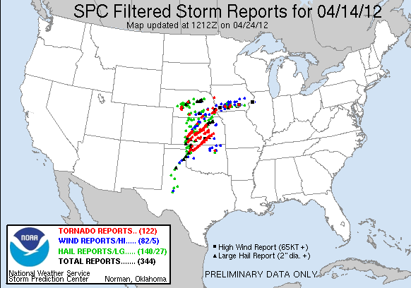
Here is the storm reports (top) and the 0z analysis (bottom):


We should have dropped south. We probably could have caught the Salina tornado. However, at the time, I thought the morning convection would have affected northern Kansas just as bad as southern NE. I thought that the best play was to get to the dryline. We also could have gone North to the North Platt tornado, but I didn't think a storm north of the warm front would produce anything long enough for us to catch it. This is why I call this section hind-sight. As you can see above, the warm front stalled and even retreated in southern NE and the dry line didn't advance into NE unitl near sunset. Morning Convection stuck around too long and cooled the surface so SB CAPE was minimized. However, this day was well foretasted!

File:Evolution of SPC Forecasts Leading to April 14, 2012.png